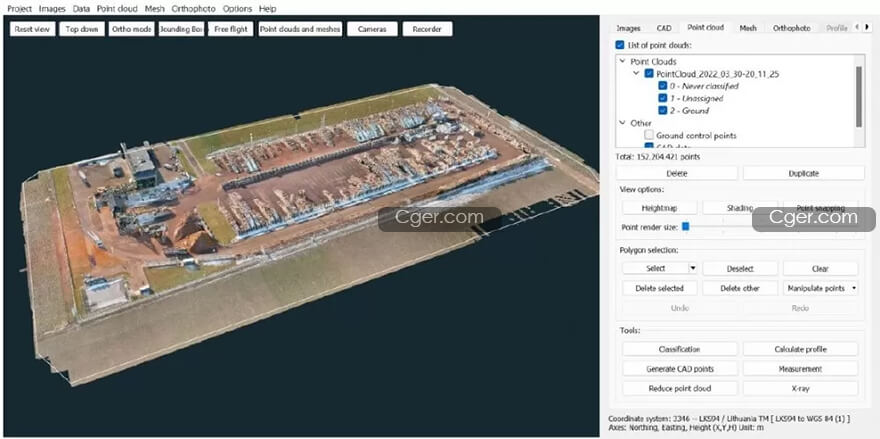
3Dsurvey v2.16.0 x64
3Dsurvey 2.17.1 Win x64 Multilingual
3Dsurvey 2.18.1 Win x64
3Dsurvey 3.0.0 Win x64 Multilingual
3Dsurvey 3 Multilingual v3.1 Win x64
无人机或手机摄影测量和图像处理软件。
我们是地理空间软件的领先国际提供商。
我们根据现实生活经验为多个行业提供解决方案,因此您可以做今天做昨天做不到的事情。
我们的一体化软件在一个地方为您提供所需的一切。它是根据第一手测量经验构建和不断更新的。
如果您正在寻找可靠的软件来节省时间并获得控制权,那么您来对地方了!
软件功能:
自动点云分类
利用我们行业领先的分类引擎和一流的点云定制工具,使您能够快速、用户友好和简单的数据分类。
数字表面模型 (DSM) 和 3D 网格模型
以逼真的数字形式重现现实。生成完全地理参考、空间导向且完整的站点配置概览,完全由您控制。
数字正射影像地图 (DOM)
以完美的地理参考细节以厘米级精度计算高分辨率数字正射影像,以进行进一步的土地测绘探索。
体积计算
以极快的速度和准确性探索体积计算。比较多个测量值,以逼真的 3D 细节可视化,并即时或随时间检测变化。
横截面和剖面线
根据点云数据绘制一条定义线,并使用用户定义的间隔计算单个垂直横截面或多个横向轮廓。
集成的 CAD 工具
集成的CAD环境使您能够在没有任何专门的第三方软件的情况下完成项目。它包括所有强大的图层样式工具!

Photogrammetry and image processing for Drone
We are a leading, international provider of geospatial software.
We provide solutions for multiple industries based on real-life experience so you can do today what you couldn’t do yesterday.
Our all-in-one software gives you everything you need in one place. It is built and constantly updated based on first-hand surveying experience.
If you’re looking for reliable software to save time and gain control you are in the right place!
Automated Point Cloud Classification
Leverage our industry-leading classification engine with best-in-class point cloud customization tools enabling you fast, user-friendly and simple data classification.
Digital Surface Models (DSM) and 3D Mesh Models
Recreate reality in photorealistic digital form. Generate a fully geo-referenced, spatially orientated, and complete overview of your site configuration, entirely under your control.
Digital Orthophoto Maps (DOM)
Calculate high-resolution digital orthophotos with cm-grade precision in perfect geo-referenced detail for further land surveying and mapping exploration.
Volume Calculation
Explore volumetric calculations with great speed and accuracy. Compare multiple measurements, visualize in realistic 3D detail, and detect changes on the fly or over time.
Cross Sections and Profile Lines
Draw a definition line and calculate single vertical cross-sections or multiple transverse profiles with user-defined intervals from your point cloud data.
Integrated CAD Tools
The integrated CAD environment enables you to finish your projects without any specialized third-party software. It includes all the powerful layer-style tools!
描述:
标签: 点云 扫描 地理 建模 生成 软件 数字 模型 照片建模分类:资源 > 软件资源 > 软件资源:未分类
发布:CGer | 查看: | 发表时间:2022/11/30 9:53:36 | 更新时间:2025/4/21 10:18:49
○ 因利息系统长期被人利用漏洞刷取CG点,目前取消利息功能,作为补偿,每个已存在账号额外一次性补偿当前余额的 30% ,后续充值赠送百分比提高 100% (10元+6%,20元+10%,50元+16%,100元+20%,200元+30%,暂定),请知悉。 ○ 充值或账号问题请【点击这里联系站长】 |
| 常见问题,点击查询: | ||
| ●CGer(Cg儿)资源下载帮助 | ||
| ●资源名词解释 | ||
| ●注册/登陆问题 | ||
| ●充值出错/修改密码/忘记密码 | ||
| ●充值赠送系统 | ||
| ●文件解压出错/解压密码 | ||
| ●Payment with Paypal | ||
| ●哪些资源会被列为付费资源 | ||
| ●为何要充值解锁 | ||
| ●免责条款 | ||
| ●联系站长(联系站长前请先仔细阅读 免责条款 ,网站只提供资源,不提供软件安装等服务!) | ||


